Sanborn Fire Insurance Maps
Beginning in 1866, the Sanborn Map Company began creating detailed maps of many U.S. towns. For over a hundred years they sold these maps to fire insurance companies to help them assess the risk of fire.
Sanborn maps show mainly streets and structures and where water mains were located, the kind of things anyone interested in fire protection would want to know. They show lot numbers, homes, outbuildings, businesses, schools, factories, churches, and hotels. They often showed what the building was made of (i.e. wood, or brick), what the roof was made of, how many stories it had, and what kind of heat source it had. For businesses, it often the type of business: dry goods, bakery, blacksmith, print shop etc. Rarely do they have any identifying information, though hotels and churches were often given their proper names.
Still, if you are looking for the history of a particular building, and know where it is exactly, then they can be very interesting.
This is especially true because every decade or so the Sanborn Company would re-draw their maps, often expanding their scope, and are a great way to see how towns grew over the years. You can also sometimes see how a home might have been expanded, with additions, porches, or garages being added over the years.
They are, however, rather limited in scope. In the Luce County area, only Newberry was large enough to get a Sanborn Map, and it didn’t even show all of Newberry, just most of it.
The Sanborn Company drew maps of Newberry in 1893, 1900, 1906, 1917, and 1927. The first four are available for free at the Library of Congress website. The year 1927, still being under copyright, is not free, but a black and white copy may be available from the Heritage Quest service, provided by many Michigan libraries.
Maps for the years 1893 and 1900 can be located here and here.
Both of these maps are only three sheets, and only show Newberry from the railroad tracks south to Truman, west to just past Phelps, and east to Parmalee and the Furnace. They also include the industrial and business sections of Dollarville.
Maps for the years 1906 and 1917 can be located here and here. These two maps expand their coverage of the town west to Robinson and south to Harrie. The 1917 map goes even a little bit further giving a tiny bit of Sherman and McMillan Avenue. It does drop Dollarville though, as this was after the fire and not much was left.
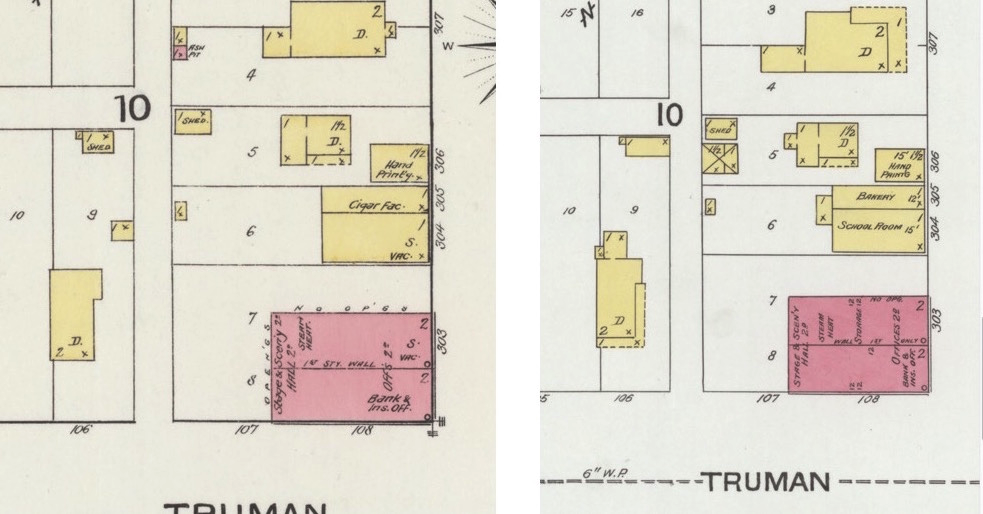
Here we have the northwest corner of Truman and Newberry avenue (1893 on the left and 1900 on the right). The pink building is the Newberry State Bank. It is pink because it is built of brick. The notes written on it indicate the building was heated by steam. It contained a bank and insurance office, and also a stage and scenery (for the opera house on the second floor).

To the west of the bank building, across the alley, we can see a dwelling house. It is yellow because it is of frame (wood) construction. In 1893 this house had two stories, and two outbuildings. One is shed. Could the other be an outhouse? On the right we can see that by 1900 this house had put an extension on the back, enlarged the shed, and ditched the outhouse. They also appeared to have added a one-story porch on the front.
To the north of the bank is the building that today houses the Newberry News. In 1893 half of it had a cigar factory and the other was vacant. In 1900 half of it was a bakery and the other half was an overflow schoolroom.
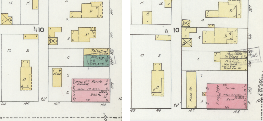
Next we have the same corner in 1906 (left) and 1917 (right). In both years the bank was sharing space with a furniture store (Beaulieu’s). It also had a warehouse, which had become much larger by 1917.

By 1906 the Newberry News had moved into half of its present location, although it shared space with a tailor. It owned a “gasoline engine,” presumably for printing (It is also colored blue or green which would indicate a stone building, but that is a mistake). By 1917 the tailor had moved out and a plumber/tin shop had moved in. It also gained a back shed.
Other Upper Peninsulas towns with Sanborn maps include the Soo, Manistique, St. Ignace, and Munising. All are larger communities… except….
Interestingly, there is just one for Seney, from 1895. It runs from George Street to Grand Street, from “Lewis Street” south to “Main Street” (neither of which seem to exist anymore). See it here.